
Trails & Hiking in Mount Vernon

Mount Vernon offers 50+ easy-access and multi-purpose trails. Walk with a partner for fun, friendship and safety. Enjoy year-round hiking on an extensive system of hiking trails through city parks and greenways, where both the Skagit River and mountain views are plentiful.
There’s so much to see and experience out on Mount Vernon and Skagit County. The Skagit County Trail Guide provides a comprehensive list and map of walking trails throughout the county.
- Kiwanis Park Boardwalk
- The raised boardwalk travels through park wetlands connecting Broadway to 20th Street. The trail is wheelchair access accessible. The trail is an easy .20 mile one way.
- Kulshan Trail
- A multi-use paved trail that connects Mount Vernon’s downtown area with commercial and residential areas to the east. The trail passes by several schools, salmon rearing ponds, natural areas, and the Bakerview Park complex. Bicycle commuters, walkers and skaters enjoy the multi-use trail. The trail is easy 2.5 miles and Kulshan trail corridor extends from the downtown Mount Vernon Skagit Riverwalk trail and Lion’s park east past Waugh Road.
- Little Mountain Trails
- Little Mountain Park offers 11 miles of multi-purpose trails. You will find a network of trails located on 517 acres of diverse terrain. Little Mountain Park offers views of western Skagit Valley, Puget Sound and the Olympic Mountains. Multi-use and hiker-only trail heads can be accessed.
- Eaglemont Trail
- The moderate 0.8 miles located in the Eaglemont neighborhood. The out & back gravel pathway, which includes a steep slope, passes by wetlands and a beaver pond.
- Edgewater Park
- Located on the westside part of Mount Vernon, the easy 0.25 mile trail passes a series of paved and unpaved areas along the Skagit River in Edgewater Park. the trail passes by artwork and playground.
- Hillcrest park
- Hillcrest Park hosts a moderate 0.25 mile loop located within a park. Stroll through the wooded area of the lower Hillcrest Park and you forget you are in city park.

- Maddox Creek Trails
- A moderate 0.75 miles, the Maddox trail is a series of paved and gravel pathways through the woods and hills of the Maddox Creek neighborhood.
- Trumpeter Trail
- The easy 1.1 mile trail, is an easy stroll on a paved multi-use trail. Bicycle commuters, walkers and skaters all enjoy this route.
- Riverloop Trail
- The trail begins behind the northwest corner of Walmart. An easy .9 mile round trip, the beginning portion of the trail is paved and turns to gravel as you head south passing a storm water pond on your left. The graveled potion of the trail makes a couple of gentle turns leading you up a slight incline to a pond, bringing you back to the same paved portion of the trail where you began.
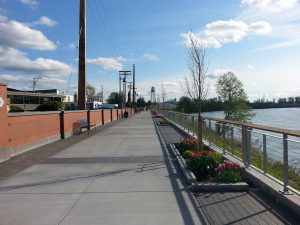
- Skagit River
- Take a stroll on foot or on bike at the Skagit Riverwalk overlooking the Skagit River. Parking available at both the south and north ends of the Riverwalk.
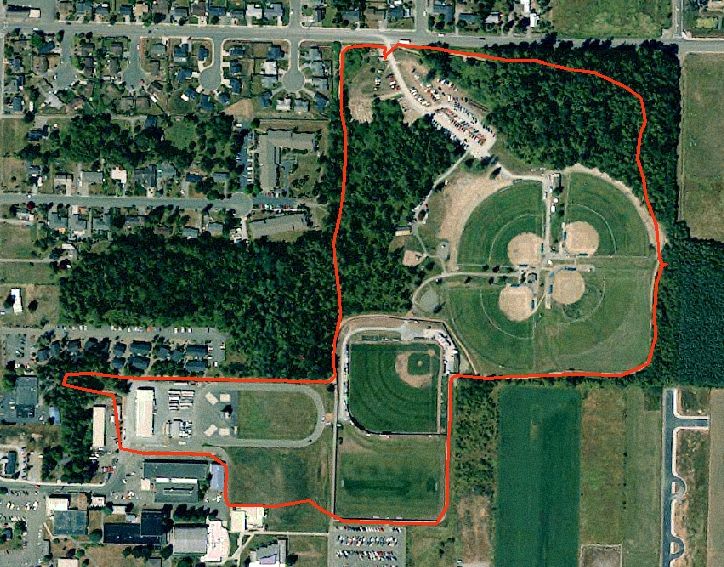
- Skagit County Playfields Trail
- Access from the Skagit Valley College, part of a 25-acre complex provides a mostly unpaved fitness trail used for walking and jogging. This trail makes a loop around the perimeter of the athletic field complex and college campus. The trail is about 1.5 miles.
- Ted Reep Trail
- The trail starts off the field at the northwest of the lower Salem Lutheran Church parking lot. The trail rounds along the field west of the church before turning right into the tall grass. At the fork in the trail follow the main trail to the left. This gently winding dirt trail will take you through a wooded area of native vegetation before coming to a clearing with a beautiful view of the Skagit River. The trail is 1.4 miles one way and visitors should use caution as the trail and terrain are impacted by the river levels and are closed during flooding.
Other options include:
Pacific Northwest National Scenic Trail covers 13 counties, three states and 1,200 miles from the Continental Divide to the Pacific Ocean. In our area, the trail comes through the Mount Baker Wilderness down to the shores of Puget Sound. In Skagit County, it follows along the dikes and through the farmlands, across Fidalgo Island and over Deception Pass Bridge to Whidbey Island.
Mount Erie at Ray Auld Drive and Heart Lake Road in Anacortes is a 160-acre park. It includes the summit of Mount Erie, the highest point of Fidalgo Island and is part of the former Anacortes watershed. You can either drive halfway or all the way to the top of Mount Erie where there are lookouts with interpretive signage and a small parking area. Or, leave your car in the parking lot at the base and hike trails to Sugarloaf and/or Mount Erie in the surrounding Community Forest Lands. Maps are available for purchase at the Anacortes Visitor Center.
Skagit River Watershed Letterbox Trail is a cross between geocaching and a scavenger hunt. Participants follow clues to discover hidden letterboxes which include a journal for stamping and a stamp or stickers for participants to place in their own journal. Participants also collect a “special word” to record at each site.